Our First Visit to Naan
in Northern Thailand
(Dec 29, 2012 - Jan 1, 2013)
Day Two

Map edited from the original at:
http://en.wikipedia.org/wiki/Phitsanulok
Sun. Dec 30, 2012 (B.E. 2555) : From Phitsanulok to Naan
Following the exhausting 12-hour road trip on Dec-29, a relaxing, restful, and lazy morning was a must! By now Naan was merely 290 kms away (less than 190 miles). No hurries.
After a super late brunch we packed and checked out of the hotel. Next, we wanted to have a quick look see at "Central Plaza Phitsanulok", which was the big shopping center that we had passed by on our arrival. It was not far off.
Prior to this trip I had never thought that the province of Phitsanulok had attractive amenities of the modern world, not to mention the biggest shopping center in the north-northeast!
• Travel books on Phitsanulok usually have lengthy descriptions of many wat (temples) in this province. Apart from wats it is always about the battles fought in this region in ancient times.
This had made me wonder what the province had besides wat, wat, and wats. "Do they have large-scale burnt down ruins similar to those in Sukhothai and Ayutthaya?", thought I.
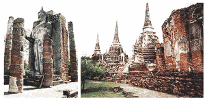
The ruins: Sukhothai (left), Ayutthaya (right)
• A few years ago while on Route 12 between Phitsanulok and Petchaboon Provinces our car drove past some highland minorities in their traditional clothing. It was on a rather desolate section of the road. These people were on foot, carrying with them big sacks of dry wood. It was as if they had time-travelled from the far past into this century. If for whatever reasons they still cling to their old lifestyle then modernity might not happen in the area.
• A Hmong refugee camp had existed for decades in the mountainous area in Petchaboon next to the border of Petchaboon-Phitsanulok. Prior to its closure in December 2009 the Thai army made a swift repatriation of the remaining thousands "refugees" back to Laos. These disheartened detainees had never been granted refugee status and the entitled benefits. For the authority, they were just asylum seekers held in custody. It could have been a relief to see them go. The bleak deserted camp with nothing but rotten huts and unpaved roads might be made a tourist attraction. People coming to Phitsanulok may want to cross over to Petchaboon to visit this heart breaking place.
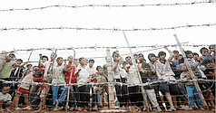
Refugees about to be deported (Dec-2009)
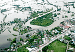
• Somewhere in the province of Phitsanulok there are villages that always get severely inundated at the onset of our annual flooding season. "Bang Ragam" is among them. The name literally means "much suffering".
Such had been my impression of Phitsanulok. How incomplete!!!!!
Back to the reality...
The hustle and bustle on the streets from the stylish Amarin Lagoon Hotel to the posh Central Plaza was no difference from what we often encountered in Bangkok – except that in this city of Phitsanulok there were many motorbikes stacked up with three persons, and most of these people wore no helmets!
I spotted a taxi with the name "Taxi Phitsanulok" on its doors. Wow, cool! I had never seen any local taxis except in Bangkok and its vicinity.
Central Plaza had a long rectangular pond next to its outdoor parking lot. From there we could see mountains in the distance. Such luxury does not exist in Bangkok! First off, we do not have mountains. Secondly, any spacious area of this kind is more likely converted to a parking lot, market stalls, or event booths.
Once inside the air-cond Plaza, we immediately felt totally "at home": every shop and store looked familiar! The place was as crowded as the way it would be in any shopping centers in Bangkok during the weekends. The goods and their prices were nearly the same as those in Bangkok, too. My older son Tony told me he had almost thought he was back in Bangna, LOL!
The only difference was in Naan the mountains that we could see from the shopping center's windows and parking lot were real.
What a shame we could not stay here all day....
We left with some lunch boxes and snacks of our usual choices. Better stock up just in case! In no time we were at Indochine Intersection where it displayed distances to the cities in the surrounding countries. Here, the blazing heat at a little past 1pm was exactly the same as what we always felt in the afternoons in Bangkok. Even this far up north we still couldn't detect any signs of winter!

After a left turn at Indochine Intersection we became the only one on the road that stretched for miles. What a drastic change! Other people heading this same way for Naan must have left hours ago!
Along the way we saw sugar cane farms, rice paddies, and many other plants. They were so green! In contrast, the yellowish brown hills beyond appeared extremely dry. Could it be that the irrigation system down here worked much better than the natural way up there on the hills? Possible...
Around two o'clock we started going up the mountain. Before long the steep climbs were bringing fast-increasing stress to our ears. It was a relief when we stopped for a red light. The name of that intersection was "Naam-Ang" (literally, "tub water"). Such funny name!
According to the map we had entered the province of Uttaradit. There was a road sign pointing to "Tron". Wow! What if this Tron was as surreal as what we saw in Tron movies and games?
"TRON AND TRON"
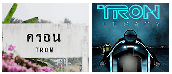
Left : Photobucket Right : imageshack
The town of Tron had been around long before King Rama V's visit to this place in the Buddhist Era of 2444 (A.D. 1901) (Wikipedia: อำเภอตรอน).
Obviously our Tron is much older than the surreal Tron!
One website introducing Tron (ท่องเที่ยวอำเภอตรอน) says nowadays the town is divided into a few districts with more than 40 villages scattering on both sides of Naan River. There is a train station in Tron. The region has lots of sugar cane plantations. A lake called Tub-kradaan is in the area. See Tron pics at Google.
They really have a big *TUB* of water, hahaha!
We moved on. The next intersection had signs that said turn left for Uttaradit Downtown, turn right for Phrae and Lamphang. We went right.
This soon led to more and more uphill driving! Gradually there were nothing besides trees. Only tall trees and dense vegetation. No other humans or cars. The place could be creepy after dark!
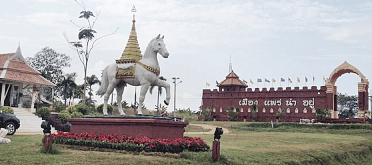
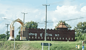
At 3:00 we came to a wide open space with traces of present-day civilization. On both sides of the main road stood two gigantic fortress-style walls with words on them: "Phrae is a nice town" and "Gateway to Lanna". In front of a wall there was a huge (and cute) white horse with a royal crown on its back:

https://irs3.4sqi.net
https://fbcdn-sphotos
Photobucket
"The Gateway to Lanna is in Denchai in the province of Phrae.... Its walls are 20 meters long and 8 meters wide, ..." said the narrator in the video above.
This, however, did not clear my doubts:
Why a Gateway here in Denchai, Phrae? What about the horse?
Thanks to the internet, here are the answers:
At the dawn of 20th century a large-scale robbery led by dozens of an ethnic minority broke out in Phrae. It quickly escalated to an uncontrollable insurgency. The King sent troops from Uttaradit in an attempt to restore the order. They encamped in the village of Den, which was located on an elevated mound. Den usually means "outstanding". The fightings went on for months before the rebellion was completely put down. It was devastating for both sides.
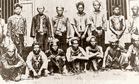
The captured insurgents
Phrae, 1902 (or B.E. 2445)
(Wikipedia: - กบฎเงี้ยว)
Here is a very good in-depth review (in Thai) : เหตุการณ์กบฎเงี้ยว ๒๔๔๕
written by a historian priest, พระครูปลัดสุวัฒนจริยคุณ (โยธิน ฐานิสฺสโร, ทิพย์นวล)
After this atrocious incident, the winning side added the word Chai (= victory) to the village's original name of Den to commemorate this hard-earned triump. During the reign of King Rama V, a train station was built here in Denchai, making it much easier to reach Lamphang and other places up north (formerly the Kingdom of Lanna). In this way, Denchai became the portal to the north, or the "Gateway to Lanna". Even the Thai and the Japanese military forces used to station in Denchai during WWI, though only for a short period of time. (Wungfon.com : อำเภอเด่นชัย )
Lanna (purple)
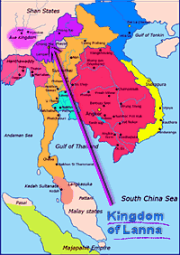
Map edited from:
http://en.wikipedia.org/wiki/Lanna
The white horse was the province's seal:

http://en.wikipedia.org/wiki/Phrae_Province
Legend has it that the rulers of Phrae and Naan "were brothers, and met at a mountain to decide about the boundary between their lands. The ruler of Nan went there on a buffalo, while the ruler of Phrae went there on a horse. " (Wikipedia).
OK... Enough of the history! (Do I get an A+? LOL!)
Back to our journey...
We took a break at the next gas station. Still very hot at 3:10 p.m. Against a blue sky we saw paddy fields, coconut trees, banana plants, and rolling hills. Such gorgeous view for a gas station! Naan must be behind one of those mountains.....
Up the moutains here we come..!
The next two hours we saw nothing except trees and grasses. There were no more gas stations or towns until we reached Wiang Sa three-way intersection. Here we saw a roadside open-air fresh market swarmed with shoppers. There was a Tesco Lotus not far from that spot. Our map said we were in the central part of Naan Province. Yippeee!!!!! We made it!
We took Route "AH13" for the town of Naan. The entire highway was under expansion from two to four lanes.
My questions: What does AH mean? Asian Highway? Was the expansion one of the projects for the upcoming AEC?
Again, thanks to the internet, I found the answers:

Edited from the picture at:
Sanook.com: ทางหลวงสายเอเชีย
AH13 is 730 km (456 miles), with about 557 km in Thailand. It starts from Oudomxai in Laos (on AH12), enters Thailand at Baan Huay Goan in Naan, goes through Naan, Phrae, Uttaradit, Phitsanulok, Phichit, and joins AH2 in Nakhon Sawan. (Wikipedia: ทางหลวงสายเอเชีย)
"The Asian Highway (AH) project, also known as the Great Asian Highway, is a cooperative project among countries in Asia and Europe and the United Nations Economic and Social Commission for Asia and the Pacific (ESCAP), to improve the highway systems in Asia. " [...] "Agreements have been signed by 32 countries to allow the highway to cross the continent and also reach to Europe."
(Wikipedia)
"The ASEAN Economic Community (AEC) shall be the goal of regional economic integration by 2015. "... "[AEC ]will transform ASEAN into a region with free movement of goods, services, investment, skilled labour, and freer flow of capital."
(www.asean.org)
Looks like we will see great changes very soon! Hope it's for the better...
At about 5:20 p.m. we saw a sign: "Slow Down. Palace Ahead." Seconds later we were passing by a Royal Residence with (seemingly) formidable soldiers guarding the entrance. A junior scout camping site was on the other side of the road. Both these two places had impressive fences. How I wish we had slowed down to take some photos!
10 minutes later we were in front of the Provincial Judge's Residence. It looked majestic! We had seen similar governmental VIPs' residences in the town of Nakon Panom. They spread elegantly in a row along the road facing Mae Khong River. ("Upper Isan, Dec-2009": UpperIsan3.htm"> I need to move this page to my site at neocities soon
This one in Naan did not face a river but there were a few stalls just outside its fence selling piles of golden skinned oranges. These were so appealing that we had to pull over and buy some.
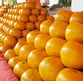
Photo from
nansociety.com
Most tourist guidebooks mentioned these oranges:
Naan's "leading agricultural produce is the Som Si Thong (golden oranges) (ส้มสีทอง), which are of the same species as oranges of the Central Plain. Because of climatic differences, the local version is golden-skinned and more aromatic. They are in season in December." (Wikipedia)
Now we had better get to our resort hotel. It should be in the vicinity! We asked around and were told it was in the soi (= small lane) by one Tesco Lotus that we had just passed.
Weeks before, we had done some online searches and decided to book a resort with the name "Huan Pak Jai" (เฮือนพักใจ๋). The name sounded interesting. Huan = ruan = residence, or a house. Pak = to rest. Jai = the heart, or the mind. This place could be relaxing...
The soi by Tesco Lotus was narrow and curvy. Fortunately there were hardly any cars. We went in, made a few turns, and came to a gated premises with beautiful houses. It was so quiet. Amazing: there were no guards at the gate! This town probably had no thieves or robbers! How nice!
We entered. A cluster of traditional Thai style houses caught our attention. Their fine design looked quite different from the other home units inside this gated community. Were these Huan Pak Jai's guestrooms? What an unusual location for a resort!
A lady emerged from one of those Thai style houses and greeted us. She gave us the room keys and a Naan Province Tourist Map. We were told the resort had only 8 units and were fully booked. The rest of the houses were private residences.
– Huan Pak Jai Resort –
(All pics were taken on Dec-31, 2012 and Jan-1, 2013.)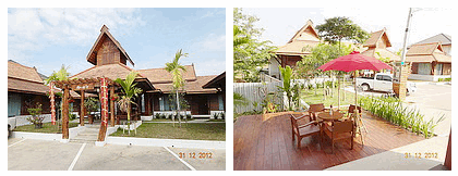
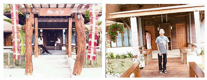
Row 1 – Left: The entrance to the guestrooms at Huan Pak Jai. Right: View from the terrace (breakfast area). Our rooms were under the roof on the left.
Row 2 – Me, Tony, and Ken in front of our rooms.
For bigger pictures (8 photos): Go to my Facebook.
Soon it was getting dark. We were too tired to explore unfamiliar eateries so we ended up having dinner at MK restaurant in Tesco Lotus on our soi. The food and service at any MK's had never disappointed us.

After dinner we drove around for a while. The town of Naan was indeed small and quiet as what all the travel info said. There were many old wats (temples) that looked fabulously enchanting in the dark. Wat Phumin was one of them:
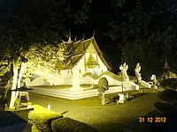
(Picture taken by Sompote on Dec-31, 2012)
We determined to take plenty of pictures the next day. Good night Naan!

