Our First Visit to Naan
in Northern Thailand
(Dec 29, 2012 - Jan 1, 2013)
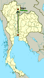
Naan (officially spelled as "Nan") is a province in northern Thailand. It is separated from Laos and other Thai provinces by mountains. It became part of Thailand (or "Siam") in the year 1931, which was not that long ago!
The map in the above was from Wikipedia (Nan,Thailand).
I added one more red dot showing the location of Bangkok and an arrow between the two places.
This would be our first visit to the province. The "capital" ("Amphoe Mueang") of this province is also called Naan, or "Mueang Nan district". According to all the travel books and articles, it is a small and quiet town.
Day One
Sat. Dec 29, 2012 (B.E. 2555) : From Bangkok to Phitsanulok
We left home around 11:30. It was sunny in Bangna district in Bangkok, and the outdoor temperature was higher than 34C (= more than 93F). Very warm! Hot, actually. Winter, where are you?
Our first mission: to eat. We went to "Tesco Lotus Bangna", one of those superstore style shopping malls on Bangna-Trad road. There we discovered an unfamiliar Japanese restaurant "Kakashi" and decided to give it a try.
"Kakashi is a Japanese word that means a scare crow. It protects the rice in the paddie fields. Rice is very important and needs special protection, ... "
Said the ads on the walls and in the menus of the restaurant. How touching, and so very Japanese! Their logo is, as expected, terribly cute. How could such a cute kakashi "scare away" any crows? (^_^)

Oops, am I doing a free ad for them? Hahaha! But why not? The food was good anyways! How come we had not heard of it before? They said they opened six months ago!
Content and full, we were ready for the real journey. As usual all year round, winter or not, the sky was crystal blue, the sun was shining bright, and it was scorching hot outside! For us, this was no big deal. Naan, here we come.....!
We headed for the outbound Ring Road, which was separated from the local roads by short and sturdy walls on both sides. It was made free of charge for a few days during this holiday season.
As expected, soon we were trapped in a traffic jam. No big deal! Happens every holiday season, we thought. But it was only 1 p.m.! The "jam" could be more serious than what we had anticipated. Gradually we were spending longer and longer time waiting than moving forward.
Forget about the speed!
More and more cars and trucks pull over to the green on the shaded side. In this country some pick-up trucks have no roofs at the back and some cars have poor air-cond and other acute or chronic engine problems. People got out and took refuge in the shade along the wall.
A few men were lining up facing the long wall. O-oh... Eeeuuuwwww! Obviously these poor souls could not make it till they reached the restrooms at the next rest area....!
Around 2:38 p.m. we reached Saraburi-Ayutthaya intersection. Still lots of cars.
All were proceeding at the speed of a dehydrated crawling snail....
Enough of the crawl! We chose the seemingly less congested way and headed for Ayutthaya. Unfortunately, after a few curving turns, we were stunned by lotsssss of cars filling up every lane of the entire highway!!!!!
No choice. We had to move forward slowwwwly, inch by inch ....
At 3 p.m. we took a break at a big rest area near Tung Bua Chom in Ayutthaya Province. As soon as we stepped out of our car we spotted an Angry Bird towel hanging above one of the shops.
LOL! This unhappy face is all over the Kingdom! I noticed stalls selling knives and daggers. It reminded me that Ayutthaya was well-known for making these items since ancient time.
We stepped inside. The place had all kinds of shops and stalls! There were tables and benches in the center part. Most of the seats were occupied. There were waiting lines here and there. The entire place was saturated with the smell of food and spices, and the sweet aroma of coffee and cakes. The cooks were busy, so were the customers. Many were talking loudly. Some tapped their smart phones and tablets with great concentration. Thanks to Steve Jobs, Facebook, WhatsApp, Line, and what not, these days more and more people prefer to take the entire world with them wherever they go!
We left the rest area and moved slowly, slowly along with another thousands cars and trucks. Our two boys never seemed to be bothered with this traffic jam at all as they had their smart phones and tablets to amuse themselves most of the time.
At 4:30 p.m. we came to Lopburi-Petchaboon intersection. Most of the cars headed for the province of Petchaboon, which was NOT our way. What a relief!
By the time we reached Hin Gong district in the Province of Saraburi the sky started to dim and the blaze had lost its power. "Hin" means rocks, and "gong" means piles. As the name implies, this area has plenty of rock mountains and rock hills. Most "piles" do not seem to be very high, but I could be wrong.
Here and there along the main road in the district of Hin Gong we could see the devastated half-chipped mountains and hills. These were the remains from several decades of rock mining. The air outside looked definitely dusty. I have often wondered how the locals manage to stay healthy when there is so much dust in the air all year round!
Good thing is, a few mountains are still intact and very green. Some have caves.
Soon we passed by the entrance to a monastery called "Wat Thamkrabok". "Tham" means a cave, or caves. This temple, or monastery, is well-known for treating drug addicts.
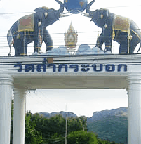
More about the detox treatment at the Monastery: Wat Thamkrabok.
The Monastery had also hosted Hmong refugees from Laos: "This continued until over 15,000 Hmong were allowed to go to the USA in 2004 and 2005 " (Wikipedia).
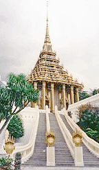
Not far off, there was another huge entrance to an even more well-known temple, "Wat Praputtabaat". "Puttabaat" means Buddha's footprint(s).
See photo below. (Source: Wikipedia.)
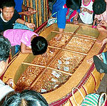
The temple has a gigantic Buddha's footprint with the size of a bathtub, and was said to have been discovered a few hundred years ago. I have no idea why the "real " Buddha's sacred footprints were that huge... See the footprint:
(Photo from thailandforvisitors.com)
We did not visit these temples. Our destination was in the north-northeast, more than 500 KM away. It had been hours since our last stop. Exhausted!
At 5 p.m. we came to a gas station in Lopburi Province. The temp outside was 36C (= more than 96F). Hottttttt! The distance from home to this spot was only 172 KM (= about 107 miles). Usually we can get to this place within 3 hours - with plenty of time for some stops on the way. Today it took us more than 5 hours!!!!!
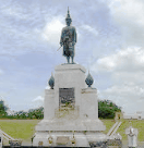
At 5:30 p.m. we passed by a large roundabout with the statue of King Narai in the center. (Photo source: panoramio.com)
Lopburi is well known for ancient temples and monkeys. "Wat Phra Prang Sam Yod" (or, Temple of Three Prangs) is at the center of yet another roundabout. It had been there for a few hundred years already. Now it is surrounded by modern townhouses, electric poles, traffic lights, and power lines. Quite an awesome contrast. ;It is even more outstanding being "infested" with spoiled monkeys. Not really safe to be among those creatures! (Pics from: Wikipedia)

"Prang Sam Yot, originally a Hindu shrine, has three prangs that represent Brahma, Vishnu, and Shiva (the Hindu trinity). It was later converted to a Buddhist shrine." (Wikipedia: Lopburi)
Near the monkey-infested isle of that roundabout we saw a statue of a gigantic gold monkey in front of a shop. (As if there weren't enough real monkeys... )
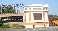
We passed by a big military base. It was in the middle of the town of Lopburi!
(Photo from: Wikipedia: ค่ายสมเด็จพระนารายณ์มหาราช)
After a few turns we found ourselves sort of confused and lost. Luckily our smart phone saved us with the map. We followed the map and went along a river (Lopburi River?), crossed a bridge and went straight, turned left to Route No. 1 that headed for a place called Kog Samrong. The time was almost 6 p.m.
The sunset view was absolutely beautiful -- albeit a bit daunting for us as we were not sure what lied ahead.
It was dark at a little past 6:30 p.m. All of a sudden the traffic slowed down.
Just as we wondered why, right there at the curve ahead of us we saw the mess of a huge truck on its side!
It had been fully loaded with sugarcanes.
Now they were scattered all over the road.
What a disaster! We hope the driver was safe! The policemen and the rescue team volunteers were already there to help easing the traffic jam. It would have been very dangerous hadn't it been for these volunteers who kept waving their flash lights. There was a swarm of onlookers. I wonder where these people emerged from.
Around 7 p.m. we reached a very big intersection with the name Tak-fa. This is in Nakhon Sawan Province (Wikipedia: Tak Fa District).
There was a 7-11's near this intersection. The open space in front of it was a very crowded market - with stalls, tables, and stools. There was a stage too.
The local's New Year party? We did not feel like stopping at this crowded market so we moved on.
Pretty soon we realized that apart from the dimly visible clock tower near the crowded market there was nothing at all - nothing but lightlessness! The entire space was obsecured in the darkness. Did we have to travel in the middle of nowhere with nothing except ultimate darkness for another hundreds of kilos before reaching the next town?! Where was everyone?
When we finally spotted a rest area on the other side of the main road we immediately made a U-turn and headed there.
The eating place looked OK so we went in and ordered. As soon as the cook started cooking the entire place became Hell. Such lousy ventilation! Worse when the electric fans were on! Those fans were supposed to repel the small flying insects and mosquitos but.... Imagine yourself sitting near a busy cook who keeps working with her hot wok full of chilli and hot oil, while the fans keep sending the heat of hot and spicy air towards you!
More customers came in and ordered. More cooking. More sneezing. The cook and the waitresses saw that we were "suffering" so they moved the fans to a different spot. How kind of them. Unfortunately this did not work. Spicy air kept invading our nostrils. Oh joy...
It would be inconsiderate to leave at once. We therefore tried our best to finish the meal as fast as we could. Good that the food tasted alright and it was not at all expensive... Lesson learned: make sure the kitchen is at a "safe" distance from where you sit.
We left the spicy shop and walked towards our car. At the middle of the parking lot we saw a truckload of live cattle. Poor cow.... Where were they taken to? How long would they be alive...?
At 8:40 p.m. we passed through Nong Bua intersection. This is still within Nakon Sawan Province. The road ahead was narrow and straight. Temp outside was 24C (=about 72F).
At almost 9 p.m. we passed by Wang Ngiu intersection in Phichit Province. A little before this we saw the sign of Kachornprasart Ostrich Farm and Vineyard.
Kachornprasart is the surname of a very well-known politician, Sanan, or Seh-Nan, who was famous for the love of good wine. The farm should belong to him or his family. Sadly, Seh-Nan had been in coma before Christmas.
Soon we came to another intersection with the name Khao Sai. There was a huge poster here that said "The people of the Phichit Province support the construction of Gaeng Sua-Dhen Dam to prevent the floods". The Gaeng Sua-Dhen project has always been controversial. The name made me think the place must be a creek with lots of rocks ("gaeng" ) and was full of tigers ("sua") jumping ("dhen" = dancing) from one rock to another....
Around 9:38 p.m. we reached Saak-lek intersection. Here we noticed strong 3G for TRUE but poor for AIS. The latter had only EDGE.... Oh well...! The road after this intersection was wider but still very dark. There were fewer cars now. We sometimes let the air from outside in - and it was so refreshing. My older son said it smelled like the start of the rain.
Another quick stop at a gas station and we continued again. The time was already 10:24 p.m. Soon we came to an intersection with the signs:
• Yangon 607 KM
• Kunming 1410 KM
• Danang 1010 KM
• Kuala Lumpur 1840 KM
The name of this intersection was "Indochine". In other articles I saw it spelled as "Indochina". It was too dark, otherwise we might have stopped to take pics.
The next intersection had refined statue of elephants. Already in Phitsanulok Province! Yay!
We drove passed Naan River and saw dazzling decorative lights. The place was ready for New Year Celebration!
Obviously Phitsanulok is a city and not a quiet town! We saw tall buildings.
There were plenty of hotel signs on the streets. Quite a few offered 390-Baht room. These could be just bed and shower.
Two bigger hotels were full when we asked them. Oh dear, we might have to spend the night in one of those 390-Baht rooms... What an adventure! Luckily, soon we found yet another bigger hotel - and with vacancy! Amarin Lagoon Hotel looked really grand. Their rooms were big and nice and not at all expensive. Nice!
It was almost midnight. End of a long exhausting day!
I know we did not take any pictures during the many-hour journey!
Good night for now.